Geospatial Enterprise — Geospatial Intelligence. Built to act.

Simple, yet intelligent
location-based systems.

Geospatial Enterprise, Inc. helps organizations and individuals solve complex location-based challenges involving people, assets, and places. We bridge the gap between domain expertise and technology by transforming data into actionable insights and applications that improve decision-making, efficiency, safety, and operational outcomes—without requiring a large in-house technology team.

Geospatial Enterprise, Inc. Texas + Virginia

Capabilities statement

GIS products.
Practical solutions.

We transform complex location and operational data into usable systems, applications, and decision-support tools.

GIS products & solutions

Modern geospatial technology designed around how organizations actually use their data.

Geospatial Enterprise, Inc. specializes in GIS architecture, data integration, indoor and facilities mapping, custom application development, spatial analytics, automation, and industry-standard data models. We modernize existing GIS environments and develop scalable geospatial products and workflows from the ground up.

Municipal addressing & public safety data

Addressing & HxGN OnCall
GIS services and data onboarding

Small cities and public safety agencies often need reliable address data without having a dedicated GIS team. We help create an initial address database, add and maintain new addresses, improve existing records, and bring that information into a practical GIS solution.

For Hexagon Safety, Infrastructure & Geospatial customers, we also prepare, transform, migrate, and validate GIS data for HxGN OnCall onboarding.

  1. 01
    Create or assess

    Build an initial address database or review existing addresses, road centerlines, schemas, coverage, and gaps.

  2. 02
    Update & standardize

    Add new addresses, correct geometry and attributes, resolve duplicates, and establish consistent data practices.

  3. 03
    Integrate & migrate

    Connect addressing data to a usable GIS solution or transform it into the required HxGN OnCall structures and workflows.

  4. 04
    Validate & maintain

    Verify completeness and usability, document the process, and provide ongoing support as communities and systems change.

01

GIS Architecture & Data Integration

Maintainable enterprise systems that connect spatial, facility, asset, and operational data.

  • Geodatabase architecture
  • Data modeling & governance
  • Enterprise GIS & cloud environments
  • System migration
  • ETL & data integration
  • Workflow automation
  • Standard & custom schemas
02

Indoor & Facilities GIS

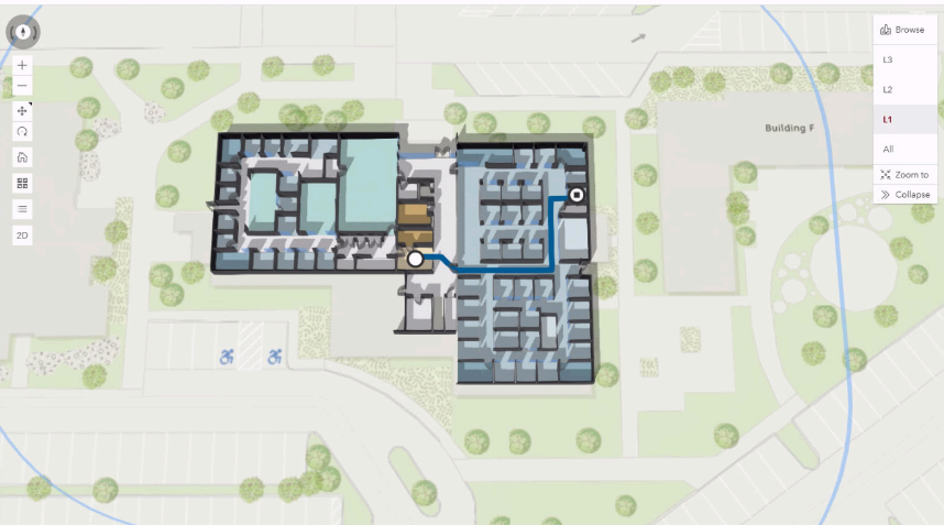
Spatial environments that connect buildings, floor plans, rooms, assets, infrastructure, and operations.

  • CAD/BIM-to-GIS integration
  • Indoor data modeling
  • Floor-aware mapping
  • Facility data integration
  • Wayfinding
  • Web-based facility applications
03

Technology, Analytics & Field Solutions

Custom technology that brings GIS into operational workflows, field programs, and better decisions.

  • Web & mobile applications
  • Dashboards, APIs & databases
  • Spatial analytics & data science
  • AI-assisted workflows
  • Drone imagery & photogrammetry
  • Remote sensing & field data collection

Standards & specialized models

  • HxGN OnCall GIS data
  • Next Generation 911
  • Seabed Survey Data Model (SSDM)
  • Custom schemas & integration frameworks
  • Asset, facility & operational data models
  • Cloud & enterprise GIS implementation

NAICS

541370
Surveying and Mapping (except Geophysical)
518210
Computing Infrastructure Providers, Data Processing, Web Hosting, and Related Services
541511
Custom Computer Programming Services
541360
Geophysical Surveying and Mapping Services
541620
Environmental Consulting Services
541715
Research and Development in the Physical, Engineering, and Life Sciences
OUR PERSPECTIVE GE

Critical thinking for the problems of tomorrow.

Proven GIS foundation

From data integration to operations.

Our expertise spans data integration, spatial databases, web GIS, cloud environments, enterprise GIS platforms, workflow automation, and custom application development—connecting information to the people and processes that use it every day.

We modernize existing GIS systems, normalize and migrate data through ETL, and align information with industry standards such as NG911 and oil-and-gas data models. Based in Texas and Virginia, we support projects remotely or on site.

“Critical thinking of today to solve the problems of tomorrow, one map at a time.”

Why Geospatial Enterprise, Inc.

Technology is only useful when it moves the mission forward.

We work across GIS architecture, data science, software engineering, and industry operations. That range lets us see the whole system—not just one tool—and build solutions that people can actually use.

01 Think spatially02 Build practically03 Transfer knowledge

Community impact

Mapping a wider path
into technology.

We are developing a community outreach program centered on geospatial literacy, technical mentorship, and practical exposure to careers in GIS, AI, and software development.

INITIATIVE IN DEVELOPMENT
∞KNOWLEDGE
MULTIPLIES

Start a conversation

Have a place-based
problem worth solving?

info@geo-ent.com ↗

Whether you are a small shop taking the first step or a growing organization modernizing existing systems, we will help you find a practical path forward.